https://archive.triblive.com/local/regional/western-pa-roads-closed-from-flooding-issues/
Western Pa. roads closed from flooding issues

• |
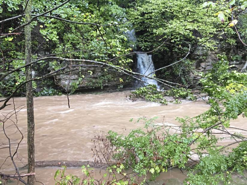
Two days of steady rain is causing flooding and swollen rivers around Western Pa. This is Girty’s Run along Babcock Boulevard in Ross on Sunday, Sept. 9, 2018.
Continuing rain from remnants of Tropical Storm Gordon forced PennDOT and other authorities to close numerous roadways around Western Pennsylvania on Monday.
The Tribune-Review will update the following list, broken down by county, as more information is released.
Allegheny County
Pittsburgh: 10 th Street Bypass in Downtown Pittsburgh, between I-279 Parkway North/Fort Duquesne Bridge and Fort Duquesne Boulevard, as well as northbound and southbound ramps from I-279. Motorists should use Fort Duquesne Boulevard to detour around the closure. Motorists on I-279 should use the ramps to Fort Duquesne Boulevard.
Pittsburgh: Becks Run Road between Brownsville Road and Agnew;
Baldwin: 3900 block of Churchview (landslide);
Bethel Park: 5700 block of Valleyview Drive; Horning at Englert Farms Road (washed out);
East Pittsburgh: Route 30 (Lincoln Highway), single lane between the Electric Avenue ramp and Center Street (landslide);
Franklin Park: 2400 block of Camp Meeting Road;
Jefferson Hills: Route 51 southbound between Coal Valley Road in Pleasant Hills Borough and Wray Large Road;
Jefferson Hills: Coal Valley Road, between Route 837 and Route 885;
McCandless: Blazier Drive;
McKeesport: West Fifth Avenue;
Mon Wharf remains closed through at least Monday;
North Braddock: Route 30 (one lane blocked by a large rock)
South Park: Stewart Road / Berryman Avenue (Route 3011) between Brownsville Road and Stoltz Road;
South Park: Stewart Road/Berryman Avenue between Brownsville Road and Brandis Avenue;
South Fayette: Boyce Road (Route 3006) between Hunting Ridge Road and Washington Road (Route 19);
South Fayette: Mayview Road/Bank Street/Station Street (Route 3005) between Willowbrook Drive and Boyce Road;
West Deer: Kaufman Road at Saxonburg Boulevard; Millerstown-Culmerville Road at Tarentum-Culmerville Road;
Homestead: River Road from East Mifflin Street to the Rankin Bridge because of a landslide. The Rankin Bridge is open.
Monroeville: Pitcairn Road is closed between Stroescheine Road and Wallace Street due to a landslide involving trees tangled in utility lines.
Westmoreland County
Murrysville: Old William Penn Highway, between Cozy Inn Cut Off and Hills Church Road;
Murrysville: Steele Road between Mamont Road and Hilty Road;
Murrysville: Borland Farm Road, Gun Club Road, Sardis Road at Crowfoot Road;
North Huntingdon: Route 993, landslide near Mt. View Place;
Sewickley Twp.: Creek Road;
Sewickley Twp.: Lowber Road
Youngwood: North 3rd Street from Depot Street to Willow Crossing
Hempfield: Route 119 near Willow Crossing Road
Hempfield: Route 136 near Rocky Mountain Road
Hempfield: Route 819 north of Greensburg
Hempfield: Barnhart Road
Hempfield: Fair Grounds Road
Hempfield: East Hillis Road
Hempfield: Cribbs Station Road
Hempfield: Hunter Road
Hempfield: Fry Hollow Road
Hempfield: Penn Valley Road
Hempfield: Glen Fox Road
Hempfield: Union Cemetery/Route 119
Hempfield: Reywayant Road
Hempfield: Wertz Road
Hempfield: Lower Fosterville Road
Hempfield: Tiple Row Road
Route 4071 Pine Run Road;
Route 2045 Two Mile;
Route 4061 Washington Road;
Route 1016 Bairdstown;
Route 1055 Hannastown Road;
Route 982
Route 3053 Parkhill Road;
Route 3037 Waltz Mill;
Route 381 (two locations);
Route 1065 St James Church Road;
Route 4089 Hilton Road;
Route 3089 Ruffsdale Road;
Route 1007 Ross Park Mountain Road;
Route 3010, Waltz Mill to Interstate 70 ramp;
Route 819, Stone Church to Wicky Lane;
Route 136 Arona Road to Harry Long Lane
Route 3029 Banning Road
Route 2012 Armburst Road
Route 3015 Turkey Hollow Road
Route 3012 Yukon Road from Adolph Lane to Highway Street
Route 1022 Crabtree Road
Route 3007 Fayette Street
Route 4034 Orr Avenue
Greensburg: Route 819 between Franklin Avenue and McLaughlin Drive
Greensburg: Route 119 near Lynch Field
Greensburg: parking lot at Aerobic Center and Kirk S. Nevin ice arena
South Greensburg: Route 119 to Adam Street
Hempfield Township: State Route 119 at Willow Crossing
Derry Township: Route 217 southbound to state Route 1025
Armstrong County
North Buffalo: Route 3007, Glade Run Road from Route 128 in Cadogan Township and Pony Farm Road;
West Franklin: Route 4035, Craigsvile Road, between Airport Road and Old Butler Road;
West Franklin: Route 3013 Mushroom Farm Road, between Route 422 and Fenelton Road;
South Bend: Route 56, between Gobblers Run Road and Shady Plain Road, Kiskiminetas Township;
Butler County
Fairview Twp.: Route 268, between Route 68 and Route 38 in Emlenton, Venango County;
Forward Twp.: Route 3028, Hartmann Road, between Route 528 and Seneca School Road, Jackson Township;
Oakland Twp.: Route 38, at the Hohn Farm Road intersection;
Fayette County
Route 2015, Nelson Road;
Route 381, Wharton Furnace Road;
Route 1049, Eighty Acres Road;
Route 1053, Arch Bridge Road;
Route 3002, Wharton Elliottsville Road;
Route 3027, Hopwood Fairchance Road;
Route 3025, Redstone Furnace Road;
V
Greene County
Route 1006, Browns Ferry Road/Ceylon Road/South Street;
Route 4005, Sawmill Road/Poland Run Road (downed tree);
Route 21, at the intersection of Route 18 & Tower Road;
Center Twp.: Route 21, in the area of intersection of West Run Road
Franklin Twp.: Route 18 in the area of the intersection of Water Dam Road
Washington County
Route 40, Chestnut Street;
Route 1006 – One Lane slide;
Route 1010;
Route 4027;
Route 481 – Peno’s Plaza;
Route 2023;
Route 2019;
Source: PennDOT, county authorities, Tribune-Review reporting